HOMEWORK ARROYOMOLINOS
FIRST PART
1.- WHERE ARE WE?
Arroyomolinos is a small village.
We are in the south-west of Europe
We are in Spain
It´s south of The Community of Madrid, between Mostoles and Navalcarnero.
The red dot shows where is Arroyomolinos.
2.- MADRID´S FRONTIERS
Madrid is bounded by Segovia to the north-west, Avila to the west, Guadalajara to the east, Cuenca to the south-east and Toledo to the south.
3.- COORDINATES
The geographic coordinates of Arroyomolinos: 40º16´9´´N 3º55´12´´O
4.- VILLAGES NEAR ARROYOMOLINOS:
Arroyomolinos found near the villages of Moraleja de Enmedio (5,1 Km.), Mostoles (7,6 Km.), Navalcarneron (8,2 Km.), El Alamo (7,5 Km.), Batres (6,5 Km.), Serranillos del Valle (7,7 Km.) and the Parque Coimbra and Cotorredondo development.
5.- FRONTIERS
Arroyomolinos is bounded by Moraleja de Enmedio to the south and east, Mostoles to the north and by Navalcarnero to the south.
6.- RELIEF AND WATER.
Arroyomolinos is in a depression due to its proximity to the Guadarrama River. The relief is made up of hills in full, except in the vicinity to the streams.
Arroyomolinos belongs to the Regional Park of the river middle course of the Guadarrama River and this runs through the municipality.
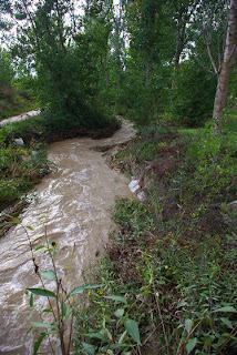
Combos´ stream, that flowing through Arroyomolinos, is surrounded by a forest called “El Pinar”. The flow is low but in the rainy season the level rise. This stream has its origin near Fuenlabrada and flows into the Guadarrama River. The Moral Major stream is a tributary of the Combo stream.
7.- CLIMATE
The climate is Mediterranean continental, with very cool winters with temperatures below the 8 degrees, night frosts and occasional snowfall. In contrast, the summer is hot with average superior to 24 degrees in July and August, often exceeding 35 degrees.
Precipitation, little abundant in general, are regularly distributed in the year, except in summer.
8.- ARROYOMOLINOS LANDSCAPE
The landscape is formed mainly by:
· Dry land crops, devoted to the cultivation of the grain.
· Scrubs, those are mostly scrub oaks.
· Pine forest, small pine reforestation.
· Holms, that is the main vegetation and
· Forest Bank.
9.- GENERAL COMMENTS
Arroyomolinos has a population of about 16200 inhabitants and this number will increase considerably in the coming years, due to the number of houses under construction.
The village is divided into three districts or neighborhoods. In the old town are the public services (Police, Council, Health Center, schools, The Tower) and a lot of chalets. In the north are Las Castañeras y Ciudad Jardín with chalets and flats. And in the east are Zarzalejo and El Bosque, here are the Cultural Center, Sports Center, The Civil Guard and the fairgrounds.
Auditorium City council
The village´s annual festival is in June, celebrating the Corpus Christi.
In education, Arroyomolinos has 7 nurseries, 4 public schools, one secondary school and 2 private schools.
Transport: Arroyomolinos has only buses as public transport (496, 497, 498, 498 Xanadu, 499 and 495) which connect to the nearby villages and Madrid.
Arroyomolinos is a very nice village, with many parks, fountains and beautiful places. The best place to live.
10.- HISTORY OF ARROYOMOLINOS
Arroyomolinos was founded during the Muslim, invasion for more was be later reconquered by the King Alfonso VI of Castile. Place was known as the Arroyo Huts.
Ruins of the waterwheel
In 1476 Juan de Oviedo took over the village and ordered the construction of a tower, now known as The Tower or Tower of the Bread. In that year, when Gonzalo Chacón besieged Arroyomolinos combating with Juan de Oviedo the Tower had not concluyed yet, so it was the latter who ordered its completion. In the 20th century the Tower was used as barn in its first two floors and dovecote in the remaining three.
Gonzalo Chacon statue
Until at the beginning of the 21st century and although it is very close to Madrid, the village had fewer inhabitants, but the high price of housing in Madrid has driven the demographic development and it has tripled its population.
SECOND PART
OUR VISIT
From de park, just below us, we could see large plains and long paths that cross it, some hills, small groups of trees, probably oaks or pines and some isolated houses. If we looked at Parque Coimbra or Xanadu (more or less in the north), in the background we could see a mountain range, which is the Guadarrama Mountains, and we could distinguish “The Globe” (2.265 m.), the second highest mountain of Navacerrada after Peñalara (2.428 m.)
Looking to the south in the distance, we could see the Navalcarnero village and a little further south, in the background and too far away, we saw the Gredos Mountains, in the Avila´s province.
(I am sorry about the photos because there are many clouds and we can´t see the mountains. I will go back to take the photos when the weather will be better)


No hay comentarios:
Publicar un comentario